The Mapping Little Rock History site can be used as a research tool for scholarly projects or academic papers or to simply learn more about the city of Little Rock and its growth over time through pictures, videos, historical maps, and more. Check out the tips and how-to's below to begin exploring Little Rock's history using the site.
For more information about features on the Mapping Little Rock History site or general questions, please visit the Features and FAQs pages.
How to...
Watch the tutorial or read the instructions below.
There are two main search functions: keyword search and address search.
Note: These search functions do not accept Boolean operators.
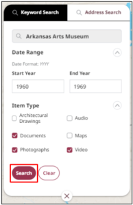
To conduct a keyword search:
- Click the Keyword Search tab in the top-left corner.
- Input a keyword or multiple keywords. There is a better chance of getting refined search results if you use descriptive keywords.
Example: “museum” -or- “Arkansas Arts Museum” - Optional: Input a Date Range in the “YYYY” format to only see artifacts within a specified timeframe.
- Optional: Adjust the Item Type filters to only see artifacts of a certain kind by clicking the checkmark to unselect it.
- Click Search. The results appear in the side panel.
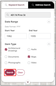
To conduct an address search:
- Click the Address Search tab in the top-left corner.
- Input a street name or an exact address.
Example: “N. Pine St.” -or- “401 N. Pine St.” - Optional: Input a Date Range in the “YYYY” format to only see artifacts within a specified timeframe.
- Optional: Adjust the Item Type filters to only see artifacts of a certain kind by clicking the checkmark to unselect it.
- Click Search. The results appear in the side panel.
Watch the tutorial or read the instructions below.
You can download any artifact in the archive.
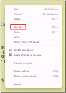
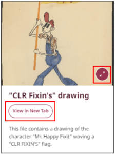
To download a photograph or architectural drawing:
- Press the Maximize icon or View in New Tab. The artifact enlarges.
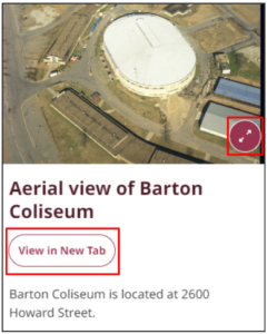
- Right-click the artifact and a menu displays. Select Save image as.
Note: Your device may use a different phrase for saving documents, such as Save to Photos. Select the appropriate option for your device.
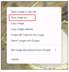
- Input the desired file name, and select Save.
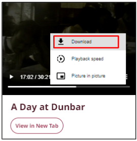
To download a video or audio recording:
- Click the three dots on the right of the artifact. A pop-up menu displays.

- Select Download. The file automatically downloads to your device.
To download a document:
- Select View in New Tab. The document opens in a new tab.
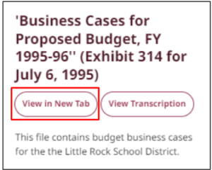
- Right-click the artifact and a menu displays. Select Save as.
Note: Your device may use a different phrase for saving documents, such as Save to Files. Select the appropriate option for your device.
- Input the desired file name, and select Save.
To download a historic map:
- Navigate to the Map Downloads page in the help center.
- Click the link of the map you want to download.
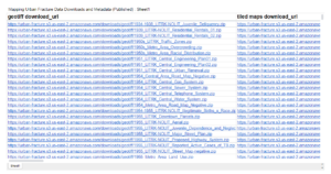
- The map automatically downloads to your device.
Watch the tutorial or read the instructions below.
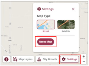
- Select Settings in the bottom-right corner of the main screen, and then select Reset Map. The map clears your progress and reverts back to its original setting.
Watch the tutorial or read the instructions below.
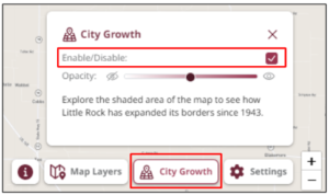
- Press the City Growth button in the bottom right corner. A pop-up box displays.
- Select the Enable/Disable checkbox to activate the feature. The annexed areas display.
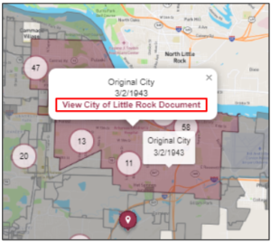
- Hover the mouse over an area to see the name of the territory and when it was annexed.
- Click an area—the View City of Little Rock Document pop-up window displays.
- Click View City of Little Rock Document. A new tab with documents from the annexation opens in the city’s site.
- Once you’re done exploring, press the City Growth button in the bottom-right corner and select the Enable/Disable checkbox to turn off the feature.
Watch the tutorial or read the instructions below.
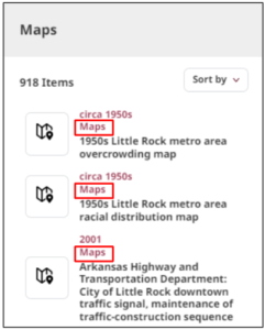
- Click Map Layers in the bottom-right corner, and select All Historic Map Layers. The side panel displays historic maps.
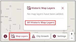
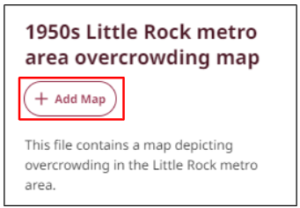
- All historic maps are labeled as Maps. Select the desired map from the results.
- Select Add Map. The historic map overlays on the current map.
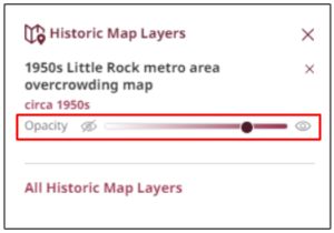
- Make the map more or less opaque by sliding the opacity dial left or right.
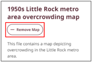
- Select Remove Map to remove the overlay.
Watch the tutorial or read the instructions below.
- Press the +/- icons in the screen’s bottom-right corner to zoom in or out, respectively.
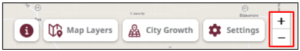
Tip: You may also zoom in or out using a trackpad or mouse wheel. Additionally, you can zoom in to an area by double-clicking on it; however, this method does not allow you to zoom out.
Watch the tutorial or read the instructions below.
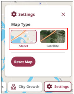
There are two map types you can use to view the current map: street and satellite. To change the map type:
- Select Settings in the bottom-right corner of the screen. A pop-up box displays.
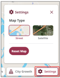
- Select your preferred map type: Street or Satellite. The map updates to reflect your selection.
Watch the tutorial or read the instructions below.
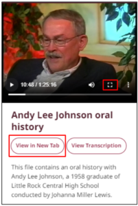
To maximize a photograph or architectural drawing:
- Select the expand icon in the bottom-right corner of the photograph or drawing. The artifact enlarges and centers on the screen.
– OR –
Select View in New Tab. The artifact enlarges and opens in a new tab.
To maximize a video:
- Select the full screen icon in the bottom-right corner of the video. The artifact enlarges and fills the screen.
– OR –
Select View in New Tab. The artifact enlarges and opens in a new tab.
To maximize a document:
- Select View in New Tab. The entire document opens in a new tab.
Watch the tutorial or read the instructions below.
The side panel includes search results and details of each artifact. To minimize the side panel without affecting your search results:
- Click the red arrow on the outer edge of the panel. The panel collapses.
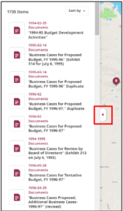
- Click the red arrow again to reopen the panel.
*Note: The Mapping Little Rock History website is the product of a National Endowment for the Humanities grant project called Mapping Urban Fracture. These two names are used interchangeably throughout this site.